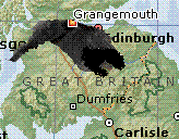
Living near the fuel storage depot and refinery of Grangemouth I was wondering what would the equivalent impact of been if Buncefield had happened here. This map was taken from Encarta and modified.
The map above has the extent of the smoke cloud from Buncefield yesterday superimposed on a map of the same scale of central Scotland. As you can see the cloud would have stretched from Glasgow to Edinburgh. In fact Irvine and possibly Troon would be under the cloud to the west.
It would have stretched almost as far as the southern coast of Loch Lomond however, Milngavie, Erskine and the majority of the Glasgow conurbation would have been under the cloud out west. To the southern extent it would have strethed as far as Biggar, Peebles and Galasheils over the the eastern end.
Edinburgh like Glasgow would be almost totally enveloped with Prestonpans and Tranent just outside the eastern shadow. Falkirk, Cumbernauld and Livingston would all be in very dense smoke. as West Lothian, North and South Lanarkshire and the southern shore of the Forth would all be in the thick of it.
In fact the Forth is a worrying addition to the Grangemouth scenario. The expolsion was heard up to 100 miles away from Brucefield. What force would that have made? Would that have created some form of tidal wave or mini-Tsunami in the Forth Estuary? The impact would have gone both up and down stream affecting Kincardine and Stirling upstream. Torry Bay on the opposite banks. Rosyth shipyard down stream, along with Bo'ness the Queensferry towns, Dalgety Bay. And what about the famous bridges themselves?
It is scary to contemplate the added affects this incident could have had at Grangemouth. It is horrifying to work out part of the area affected based on a local scenario. Even knowing that the snapshot I usedwas not the full extent of the cloud of smoke it is still a harrowing thought. I think we are very lucky that nobody was critically injured in this incident.
3 comments:
I'm totally guessing here, but I suspect it would have been worse in Scotland because of the impact a big black cloud would have had on a mountainous region.
Thanks James and you are probably correct. Plus the hills would have been more likely to funnel the plume of smoke down the valleys affecting the Clyde and Forth, Glasgow and Edinburgh more.
Unfortunately, I'm unable to model the effect of this unto the map, nor the wind direction over Scotland on Sunday, I'm not scientific enough. This is merely a fit unto a map of Scotland, if someone does produce a full 'what if' based on a Grangemouth scenario I'll be posting those findings here.
Great. Not only would my flat be enveloped, it'd probably still be smoky at work :(
I can't say I was impressed when I saw an expert of some sort on the news a few months back saying that Grangemouth would be a good target for The Terorrists in Scotland. Yeah, give them ideas why don't you...
Post a Comment